
Q: Do any Maps Show where Angband and Utumno Lay?
ANSWER: There are two maps, both made prior to the writing of The Lord of the Rings, which show the approximate locations of Angband and Utumno. These maps are not necessarily consistent with the published text of The Silmarillion and are most certainly NOT consistent with the published text (in any edition) of The Lord of the Rings.
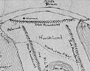
That said, in “Ambarkanta Map IV” (published in The Shaping of Middle-earth) Melkor’s fortress of Utumna/Utumno is placed directly north of the Blue Mountains, somewhat to the east of the later map’s location for Angband. Angband is described as an outpost of Utumno.
For a while, as he developed the mythical world of the “Silmarillion” (not yet named Middle-earth), J.R.R. Tolkien switched the names of the two fortresses, such that Angband became the original, earlier fortress and Utumna became the later outpost.
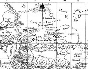
Angband, so far as I know, was only shown on the “2nd Silmarillion Map”, which was published in The Lost Road and Other Writings. Christopher Tolkien used the “2nd Silmarillion Map” as a guide for the map that he drew for the published Silmarillion but he omitted Angband from the final map.
Nonetheless, Angband’s placement on the “2nd Silmarillion Map” is consistent with all the passages in the published Silmarillion that refer to Angband and the movement of troops and peoples across the landscape.
# # #
Have you read our other Tolkien and Middle-earth Questions and Answers articles?
A more frustrating question is why it was left off.
Even more frustrating is why there was never a map with both Beleriand and middle earth, combined. Like Bilbo, I love looking at those maps.