
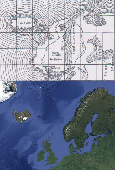
Q: Is Tol Fuin Supposed to be Iceland?
More than a thousand years ago Iceland was much warmer than it is today and about 1 quarter of the island was covered in forest. Now there are relatively few trees left in Iceland, due in part to the cooling of the climate, natural disasters, and the presence of people.
Dorthonion was a heavily forested highland which lay north of Doriath, on the southern side of Ard-galen, the great grassy plain surrounding Angband. The forests were thicker in the eastern part of Dorthonion, in the region of Ladros (possibly meaning “whispering valley” or “rustling valley”), where the Bëorians mostly lived. According to Tolkien’s description of Beleriand, this would have been one of the cooler lands inhabited by Elves and Men during the First Age.
Still, it is very difficult to show any one-to-one correlation between the geography of Middle-earth and the real world. Tolkien once lamented having invented the geography of Middle-earth first rather than using real geography as a guide for his stories. So any resemblance between Tol Fuin and Iceland — while perhaps more than coincidental — should not be taken as a significant factor. And if Tolkien did truly intend Tol Fuin to represent Iceland, given the time frame for his stories (many thousands of years ago), I would expect that he imagined it to be uninhabited during the Second and Third Ages.
By Tolkien’s chronologies, Iceland was not settled until probably sometime in the Sixth Age.
# # #
Have you read our other Tolkien and Middle-earth Questions and Answers articles?
Tol Fuin is really interesting place to speculate about, maybe it still after all thousands of years had some traces of dark enchantments which warped Dorthonion in First Age, with all those phantoms of terror strangling or pursuing to madness and black trees, a place where mixing sorcery of Sauron and powers of Melian caused crazy things that indeed in there ,,horror and madness walked” :).
In regard to the earlier question of Tol Fuin, yes, Iceland was probably in JRRT’s mind when he drew Dorthonion–yet its place on the map actually fits the ‘phantom island’ of Frisland, which used to be on maps until the 1650s:
http://en.wikipedia.org/wiki/Frisland